Tracing the Flight of the Beast in "The Dog Stars"
 |
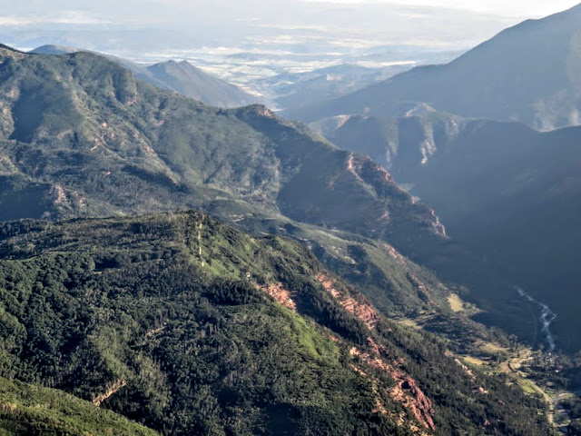
| View north from Rollins Pass, CO. |
My book Lessons from Piloting for 45 Years covers close shaves over more than four decades involving thunderstorms, mountain weather, faulty runways, equipment failures, and more.
We are not giving anything away by saying that the story begins at the Erie airport (EIK), which is just a few miles NW of Denver, CO. You learn that on the first few pages of the book. We are also not spoiling your reading of the book by saying that a trip going west from Erie across the Rockies becomes important. That trip intrigued us to the point where we drew the course on a Denver sectional, using the detailed narration in the book to identify waypoints. Learn key strategies for coping with these dangerous situations. They include two tools called Sully's Rule and Forecast Evaluation.
Now we are not going to tell what happens on that trip of the book and where it terminates. Instead, we will just talk about our route, which followed much of the flight described in the book, except that we reversed direction and started at a different airport. The reason for the reversal is simple. The Rockies typically have westerly winds. If we start in Denver, we must climb rapidly from 5,000 ft to 14,000 ft, all the while suffering from the downdraft produced by the westerly winds across the mountains. There is no way that our Zenith 601HDS, with 80 hp Rotax 912 engine, can do this.
We begin at Montrose, CO, which is NOT the terminal location of the flight in the book. We had reached Montrose after tracing the Dolores River from Cortez, CO. That trip is described in a separate post.
The takeoff at 7:30 am at Montrose goes well. The air is still cool, and the plane accelerates rapidly, lifts off, and climbs at more than 500 ft/min. Turning north, we quickly pick up the Gunnison River. Due to the blinding sun rising in the East, the river glistens like molten silver.
 |
| Gunnison River north of Montrose, CO. |
 |
| Route from Montrose, CO, left bottom, to Erie, CO, right top. |
At Bowie, CO, we turn east and follow the North Fork Gunnison River.
 |
| North Fork Gunnison River between Bowie and Oliver, CO. |
 |
| Crystal River south of Carbondale, CO. |
 |
| Mt. Sopris, 12,953 ft, south of Carbondale, CO. |
 |
| Carbondale, CO. |
 |
| Colorado River north of Dotsero, CO. |
At 14,000 ft, we can see quite far.
 |
| View south from Tabernash, CO. |
 |
| Ski slopes of Winter Park CO. |
 |
| Views north from Rollins Pass... |
Instead of landing at the Erie airport, we proceed to Greeley, CO, with two long runways offset by 90 deg. Refueling at noon, we decide to start the trip home to Dallas.
A surprise comes up in the broad expanse of Kansas. We have seen signs of aliens in Texas and New Mexico before. Now we have evidence of aliens in Kansas, not in the form of crop circles, but of dirt circles, a novel means of alien communication. We first cannot make out the drawing, but when we later turn the photo upside down, the meaning becomes clear.
 |
| Alien dirt circles in a large field, displayed upside down. |
Every post has a message. Here, we have two of them. First, if you have not read Heller's book, by all means do so. It's a terrific story. Every person to whom my wife or I have recommended the book, has come back thanking us for suggesting that great book. Second, whenever you have time, fire up your plane and fly the Colorado high country. It's a trip you will never forget.
Coda
When we mailed this post to Peter Heller, he responded:
Klaus,
How cool that you flew the route. This is one of the coolest responses to the novel I've received. Every one of your photos brought a memory--I've seen the country from that angle many times. Thanks very much for sharing this with me, and on your post. And happy flying, and reading!
Here's Triple Three Alpha in Paonia.
 |
| Peter Heller's Cessna 182, the role model for the Beast in "The Dog Stars" |
All best,
Peter
Peter Heller
Author
The Dog Stars
The Painter
from Vintage and Knopf
Contributing Editor: Outside, Men's Journal
Have any questions or feedback about this post? Please share your thoughts in the comments.
My book Lessons from Piloting for 45 Years covers close shaves over more than four decades involving thunderstorms, mountain weather, faulty runways, equipment failures, and more.
Learn key strategies for coping with these dangerous situations. They include two tools called Sully's Rule and Forecast Evaluation.


Comments
Post a Comment